Mon Prof Augmenté
Sea zones and shipping routes
Age 18 · Geography

Coastal states control a narrow territorial sea and a wider exclusive economic zone extending up to 200 nautical miles from the coast. Beyond that, the high seas are open to all states, and major shipping routes cross these zones to move goods worldwide.
This picture is part of the full library
Every lesson is open to everyone for 7 days after it is published. This one came out on October 6, 2026: its text stays readable here, and its picture opens with a subscription.
The app is free. A subscription opens every lesson, in every school year.
Age 18: open this week
Browse Age 18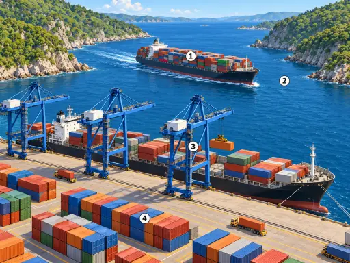

In the picture
- Territorial sea: the coastal belt where a state exercises full sovereignty.
- Exclusive economic zone: waters up to 200 nautical miles where a state has rights to resources.
- High seas: open ocean beyond national jurisdiction, free for all states.
- Shipping route: a regular path taken by cargo ships across seas and oceans.
Examples
- A fishing boat from a coastal town may need a licence to fish in its country’s exclusive economic zone.
- A container ship carrying phones and clothes follows a fixed route across the high seas between ports.
Key takeaways
- The territorial sea is narrow; the exclusive economic zone can extend to 200 nautical miles.
- The high seas are not owned by any single country and carry much of global shipping.
Quiz: Sea zones and shipping routes (Age 18)
-
How far from the coast can a state’s exclusive economic zone extend?
-
Which zone is the narrow coastal belt where a state exercises full sovereignty?
-
What does the card say is true about the high seas?
The answers, each with its explanation, are in the app. This lesson has left the free week, so its quiz is part of the subscription.
Free app, optional subscription
App Store Google Play
Carry on in the app
At least one new illustrated lesson every weekday for your child’s year, with its quiz and a reminder at 6:15 pm.
Your child’s teacher does not use My Enhanced Teacher yet?
Tell them about it