Mon Prof Augmenté
Map and Compass Race
Age 12 · Sports

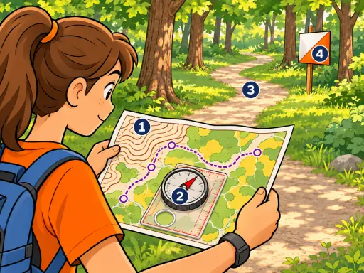
You use a map and a compass to find markers called control points in a set order. You start at the triangle, visit each circle in turn, and finish at the double circle.
This picture is part of the full library
Every lesson is open to everyone for 7 days after it is published. This one came out on October 17, 2026: its text stays readable here, and its picture opens with a subscription.
The app is free. A subscription opens every lesson, in every school year.
In the picture
- The map: a scaled drawing of paths, rocks, and vegetation.
- The thumb compass: its needle points north while the map is held flat.
- The purple line and circles: the route through control points from start to finish.
- The control flag: a marker on the ground that matches a circle on the map.
Examples
- Following a park trail map to reach a picnic table.
- Using a phone compass to walk toward a landmark in a new city.
Key takeaways
- A map and compass together help you know where you are and which way to go.
- Control points must be visited in the order shown on the map.
Quiz: Map and Compass Race (Age 12)
-
In orienteering, what two things work together to help you know where you are and which way to go?
-
In what order should you visit the control points on an orienteering course?
-
A control flag on the ground matches which symbol on the map?
The answers, each with its explanation, are in the app. This lesson has left the free week, so its quiz is part of the subscription.
Free app, optional subscription
App Store Google Play
Carry on in the app
At least one new illustrated lesson every weekday for your child’s year, with its quiz and a reminder at 6:15 pm.
Your child’s teacher does not use My Enhanced Teacher yet?
Tell them about it